Archive

Posts Tagged ‘backpacking’

Yellowstone and the search for solitude

August 31st, 2011 Comments off

I knew that Yellowstone would have hot springs and wildlife, but would I be able to find solitude there as well? The numbers didn’t look promising: america’s first national park sees over 2.5 million visitors every summer.  Still, it’s a big place, larger in area than Rhode Island, and I thought my goal was achievable.  It would simply be a matter of figuring out where to go.

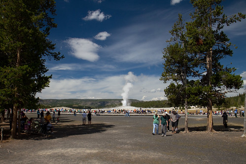
Old Faithful was not the place to get away from the unwashed masses. I had pictured the geyser being in some remote location, perhaps a half-mile hike from some dirt-lot trailhead in the wilderness.  Nope.  The reality was an enormous paved parking lot packed full of cars, trucks, and RVs.  There was enough parking there for a shopping mall, and a large one at that.

The geyser itself was in the middle of a large wood boardwalk, which was an arc set back from the aperture about 100 ft and circumscribing about 240 degrees.  Between eruptions, the boardwalk was fairly empty, but near show time, it was packed with people.  In most cases, the throngs were many rows deep.

I stuck around for two eruptions, and each time, I was amused by how many people chose to experience the event via the screens of their digital cameras instead of living it in the present.  I admit to some guilt in this regard, but I did pry myself from my technology long enough to enjoy the moment as well.

The masses of people watching Old Faithful erupt at Yellowstone

So, Old Faithful was fun to watch but in no way provided solitude.  I pressed on deeper into the park.

To the west of Old Faithful, the park road curved north.  Along the way, it passed a small parking lot at a location known as Biscuit Basin.  I decided to stop.

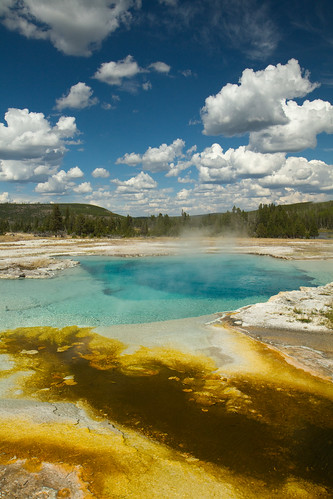
The namesake biscuit-shaped formations were destroyed in a fit of geothermal activity a long time ago.  Remaining were numerous pools of hot water, each one uniquely colored from minerals and microbes.

Hot pools, including Sapphire Pool, at Biscuit Basin in Yellowstone NP

An extensive network of boardwalks snaked through the area, both to protect the visitors from the hot geothermal features and  to protect the features from the visitors.  The numerous, numerous visitors.  No solitude there.  A different approach was needed.

I knew that I would be able to find solitude in the backcountry, but I wasn’t feeling much like backpacking.  Maybe it was my recent Denali experience; how could other places compare?  Part of it was also a general feeling of exhaustion, which was compounded by the fact that I had already been (car) camping for a few days.

In the end, I decided that I would regret not backpacking at least one night in Yellowstone.  I might never have another chance.  I plotted out a short out-and-back, about 11 miles round trip with just 1600 ft of total gain, got my permit, and set off.

It didn’t take long to reach my campsite for the evening in Seven Mile Hole — just a couple of hours — but in that short stretch I saw incredible beauty.  I had my DSLR along, so I was able to capture a bit of it, but I don’t think I did the sights justice.
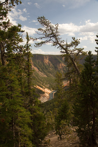
The Grand Canyon of the Yellowstone as seen from the trail to Seven Mile Hole. The river, center, was about 1000 feet below the point where this was taken.

I passed five other hikers on my way in. That was the extent of my contact with humanity: I saw nobody on my hike up and out of the Grand Canyon of the Yellowstone the next morning.

It took a while, but I found solitude in Yellowstone.
Close encounters of the bruin kind

July 21st, 2011 1 comment

Tyler was working his way along the rock face when he suddenly snapped his head back around the corner. He looked at me, eyes wide and face in a state of shock, and stuttered out a warning.

“B- B- Bears!”

I was a few feet behind on the narrow rock terrace that served as a pass between the sheer face and the raging Toklat River.  We had been backpacking in the Denali National Park backcountry for a few days and were heading down the river towards the park road, still six miles distant.  A strong wind was blowing upriver, making it unlikely that any bears around the bend would be able to smell us in our current positions.

“How close?” I asked as Tyler somehow passed me going the other way.

“Really close.  See that gravel bar in the river?”

I saw a gravel bar, but it was just yards away.  Surely that wasn’t what he meant.

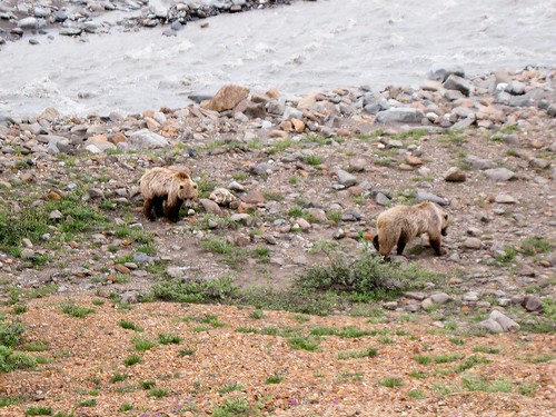
“But that’s only…” was all I could vocalize before I saw an image that will be forever burned into my memory: the head of a golden-brown grizzly bear poking around the corner, a stark contrast to the gray water and the black rock.  It was no more than 20 feet from me.

“Oh crap!” I said, and I quickly followed Tyler away from the bears.

One by one, three grizzlies sauntered around the rock face by wading through the rushing water.  Clearly, they were not concerned about being swept downstream.  It was a mother and two cubs.

Tyler and I continued our retreat while waving our hands above our heads and yelling, “Hey bear!”  The knowledge that most of Denali National Park’s grizzly bears were vegetarian provided little reassurance, as a physical encounter in our situation would have been about a mother protecting her offspring rather than predation.

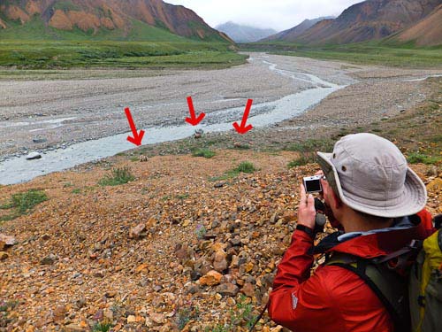
Since the bears seemed to be set on going up the bank of the river, and we couldn’t cross the river’s narrow, fast channel, our only option was to scramble up a steep talus slope.  We managed to put about 50 feet between us and the river — and thus, between us and the bears.

Grizzlies! Much closer than the ones at Banff.

Fortunately, the bears appeared to be as uninterested in us as they were in moving quickly.  They took their time wallowing up the bank, pausing for long intervals to sniff various interesting rocks and shrubs.  We continued to wave our hands and yell.

Me taking a photo of the bears. See how I'm not using a big telephoto lens? (Credit: Tyler)

Ten minutes after it started, our close encounter with one of North America’s most powerful animals came to an end.  The bears moved out of sight upriver.  Tyler and I breathed sighs of relief and continued our downriver trek.

Waterfalls

July 18th, 2011 5 comments

The extremely steep scree slopes didn’t alarm me.  Neither did the ice in the drainages, the mud, or the incessant drizzle.  What did have me a bit unsettled was simple math.

Tyler and I had crested the ridge at 5500 feet, the valley floor was at 3900 feet, and the horizontal distance between the two was about a mile.  That implied an average grade of about 30%.  However, even though the initial descent off the ridge had been rather hairy, perhaps a 60% grade, the overall path down the drainage felt nowhere near steep enough.  We had a lot of vertical distance to drop without a lot of ground left to cover.

We worked our way down the drainage in a gap that was becoming increasingly narrow.  It was cold, wet, and gray.  We were looking forward to getting to the Toklat River valley and its gravel bar so that we could set up camp and dry out.

Soon, the rocks were so close together that we were walking in the creekbed itself; a slot canyon.  I was in the lead, and Tyler was a half dozen yards behind me.  I rounded a bend, and in that moment I saw where that missing elevation went.  Ten feet in front of me, the ground dropped away and the water rushed over it.  It was a waterfall.  A bloody waterfall.  I couldn’t believe it.

I crept to the edge to better assess the situation.  The waterfall was at least 80 feet high.  As we were in a narrow sheer-faced canyon, there were no routes around the waterfall. The rock alongside the fall was totally rotten and unclimbable.  It might have been possible to climb down the fall itself, but that would have required technical climbing gear, which we lacked.  An unprotected climb would have been suicide.

I backed away from the edge as Tyler came up behind me.  I was a bit freaked and was shaking from adrenaline.

We talked it over briefly, but our options were limited.  Neither of us relished the idea of regaining the 1000 vertical feet to go back over the ridge, especially considering the loose rock at the top of that route.  Going down the waterfall was clearly out, too.  We pulled out the topo map to consider our alternatives.

Another drainage a half mile to the north of the one we were in appeared to be viable.  The trouble was that waterfalls are not usually marked on USGS quads.  Another waterfall could have easily been hiding in that drainage; the map had provided no hints to the presence of the one we had already encountered.

The pass to that drainage was 700 feet above us and about a half-mile hike.  I was still feeling a bit shaky as we turned around and began hiking back up.

At that pass, we stared into the next drainage.  We had thought that coming down from the main ridge was a hairy descent, but that had nothing on our new challenge.  The slope below us was easily 45 degrees — a 100% grade — and consisted of loose scree, dirt, and mud.

The rain continued to fall, further complicating the situation.

Gaiters were donned.  (Twice for me.  I always seem to put them on the wrong legs on my first attempt.)

We began our trek down the extremely steep, sketchy hill, half stepping and half sliding.  Very slowly.

After quite a while, we made it to a slightly less extreme stream bed, which made the downclimb marginally easier.

The feet of altitude ticked away as we continued our descent.  There were some short cascades in the stream, but those were easily managed.  So too were a pair of small waterfalls, which we were able to skirt by traversing some steep talus.  Things were going well.

We were just a few hundred feet off the floor when the rock again narrowed into a slot canyon.  We crossed our fingers, but our luck ran out.  We rounded a bend and saw… a waterfall.  Another bloody waterfall.  I couldn’t believe it.

Fortunately, that one was considerable shorter than the first at about 12 feet high.  The rock was rotten again, but some of it appeared climbable, and attempting the descent did not seem likely to be fatal even if we cratered.

Tyler and I decided to commit.

I tossed my hiking pole to the base of the fall and began to downclimb the rock next to, but not in, the water stream.  Everything went fine for the first few feet, but then what I had feared came to pass: my holds flaked off, and I fell.

I felt the rocks give away and myself grinding down the face.

Fortunately, it wasn’t a long fall, and I managed to land on my feet at the base, staggering back a bit.  The rocks I had dislodged fell harmlessly around me. Tyler yelled down to me over the roar of water to see if I was OK.

A quick assessment showed some damaged gear, a sore chest, and a bleeding knee, but no bones broken or joints twisted.  I stood there in shock for a couple of minutes.

It soon was Tyler’s turn.  He wisely chose to climb down the fall itself, in the stream of water.  The rock was better there, and my view from the base revealed many viable holds.

Still, the climb was not without risk, and from Tyler’s perspective most of the holds were invisible beneath the rushing white frothy water.  That same water also did a fabulous job of totally drenching him.  Whatever the rain had not found, the waterfall’s flow did.

Happily, Tyler made it down without incident.  He had embraced the waterfall, and it had smiled upon him.

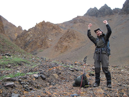
Tyler celebrates

Tyler celebrates after climbing down a waterfall

Even better, the drainage opened up wide after that point, and we encountered no more major impediments.  We successfully made it down to the Toklat River: Denali Backcountry Unit 10.

When we were getting out backpacking permit, the ranger hadn’t batted an eye at our proposed itinerary. However, when we later told people about our surprise at encountering waterfalls when going form Unit 11 to Unit 10, they almost universally smiled and nodded in amused understanding.  It felt like we were the only people in the park who didn’t know that you’re not really supposed to go from Unit 11 to Unit 10 (at least not over the ridge).  Interestingly, the Unit 10 description mentions the waterfalls and two other problems we would later have: encounters with bears and the difficulty of the pass from Unit 10 to Unit 12.  It would seem that we overlooked those details.  We learned the hard way.

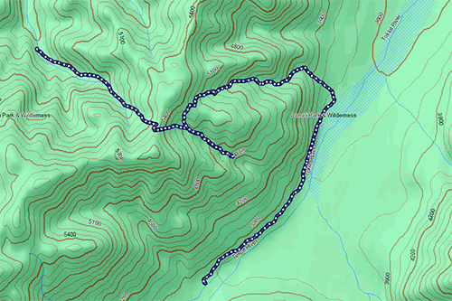
Our hike that day

Our path that day, as recorded by my GPS. Note how the topo map doesn't really indicate the presence of a waterfall. (Click for larger annotated version)

The total distance was only 4 miles or so, but those were the most difficult 4 miles of backpacking I’ve ever done.

Shadow Lake

July 10th, 2011 1 comment

I had spent the morning hiking uphill through an old pine forest.  My route mimed the path of powerful Redearth Creek, a turquoise-colored torrent rushing noisily beside me.   Everything was soaked from the rain that had besieged the area for the previous few days. The muddy trail was a testament to that, but so was the lush green moss carpeting the nearby forest floor.

At the end of my 14 km trek — not particularly taxing, even with 440 m of elevation gain — I came to Re14, the Banff National Park backcountry campground that would be my home for the night.  Like everything else, the campground was saturated.  The area where the park service had set up bear cables was particularly muddy.

Fortunately, there was a small somewhat-dry spot beneath the boughs of three giant lodgepole pines.  There I set up my Tarptent-brand, um, tarp tent.  Then I ventured out to explore nearby Shadow Lake.

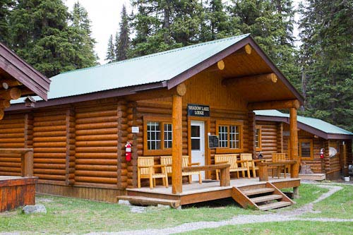
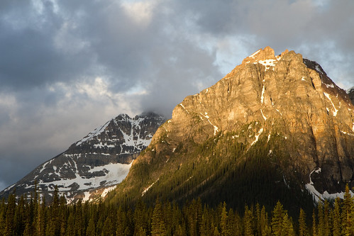
Almost immediately after I left the campground on the trail, I stumbled into Shadow Lake Lodge, a collection of a dozen beautiful log cabins in a clearing in the forest.  Glacier-topped Mt. Ball loomed large, dominating the westerly view.  The map had indicated the presence of a lodge, but it offered no other details, not even a name.

The main building at Shadow Lake Lodge

A couple of day hikers were munching on a snack at one of the lodge’s picnic tables.

“What is this place?” I asked.

“Talk to the girls inside the main building. They’ll tell you all about it,” came the reply.

And so I did.  Amy (from Australia) and Yana (from the Czech Republic) explained how the lodge had been in operation since the days of the railroad almost a century earlier.  They told me how they had just opened for the season, so there were not yet many guests.  They invited me to try the lodge’s afternoon tea service.

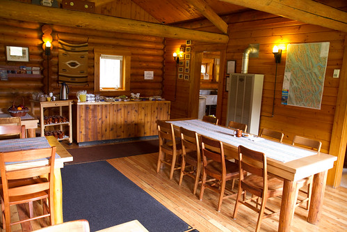
Yes, afternoon tea.  Despite being in a location that required all guests to make the same hike I had completed that morning, it was not so remote as to be uncivilized. In fact, the lodge provided breakfast, lunch, and a multi-course dinner to the guests staying overnight, in addition to the tea service.

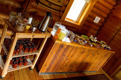
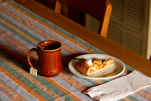
I wasn’t staying at the lodge with its fancy wood walls and roof; I was roughing it, darn it. Thus, afternoon tea cost me $15, but that seemed reasonable for such an extravagance in the backcountry.  The spread was impressive: imported cheeses, various cookies, scones, grapes, vegetables, dip, salsa, chips, apple tart, lemonade, and, of course, tea.  All of the pastries and cookies were baked on site from scratch, so the building itself smelled great.  Okay, maybe the tea service voided my “roughing it” credentials for the day.

The spread at Shadow Lake's afternoon tea

The awkward part about the experience was the lack of other people.  I was the only customer at the tea.  That left me feeling guilty about both not eating much and as well eating as much as I did.  I figured I had to try at least one of everything, but that still left enough food for a dozen non-existent people.  My inner Minnesotan was tormented.  Seemingly sensing the situation, Amy gave me a plastic baggie and told me to take some cookies for later; I happily obliged.  The Minnesotan was mollified.

Kind of lonely...

While I was sipping my second cup of tea and munching on my third helping of goodies, a day hiker came by and reported that he heard several whistles while hiking along Shadow Lake, which was located about 1 km from the lodge. He wasn’t certain that it was a human, but he knew that whistles can be distress signals, and he thought it best to inform somebody rather than let it slide.  That somebody ended up being Amy.

Here’s the thing about Amy: great person, but not exactly experienced in the backcountry.  She had come over from Australia three weeks earlier, seen an ad in the paper in Banff advertising the job at Shadow Lake Lodge, and taken it.  Despite the remoteness of the lodge, backcountry experience in the Canadian Rockies was not a prerequisite for the position.

She wisely decided to defer to the park warden on the matter of the whistling.

The lodge didn’t have a normal telephone, but it did have an old autopatch-style radio telephone.  Amy tinkered with it for a while, but she was having trouble getting it to dial the park warden’s number.  I wasn’t much help beyond offering words of encouragement.  The other staff were all away from the cabins on hikes or something, so it was up to Amy to figure it out.  She briefly considered using the lodge’s Iridium satellite phone, but the phone reported the account being invalid (huh?).  My Globalstar satellite phone would have been another option, but the next satellite pass for its operation was 25 minutes away.

Tea and tart

After 15 more minutes of screwing around, Amy finally figured out the correct sequence of DTMF tones and timing to dial the park’s number.  She related the account of the whistling to the warden.  Much to everybody’s relief, the warden said that it was almost certainly a marmot, not a person.

According to him, marmots make noises that can sound strikingly similar to those produced by artificial human whistles.  Amy and I were surprised by that, so we keyed up a Youtube video of a marmot whistling. (Despite a lack of phone service, the lodge had high-speed internet access, most likely via satellite.)  Listen for yourself.  Imagine hearing just a couple of those bursts, perhaps each for a slightly longer duration; do they not sound at least a bit human?

Later, I went for my own hike along the shore of Shadow Lake.  I got drenched by the restarted rain and chilled by the temperature at altitude; snow dotted the ground beside me. I was enjoying view of the stoic  turquoise waters and the huge glaciers feeding them when I too heard a whistle in the woods.  It was clearly a marmot, but still, the resemblance to a human whistle was enough to make me holler out “Hello! Is anybody there?”  The gentle patter of raindrops was the only reply.

I munched down a cookie and hiked back to my tent.

The view of a ridge near Mt. Ball from camp the next morning

Will it fit?

May 2nd, 2011 Comments off

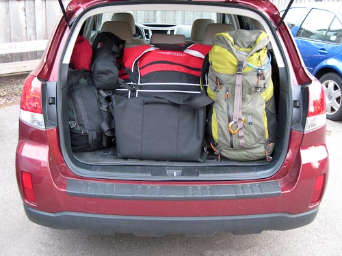
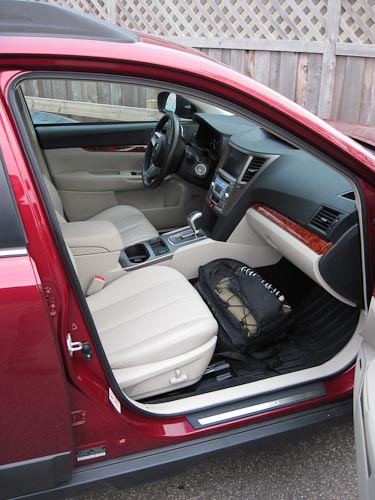
One of the questions I often get asked is, “Will everything fit?” (That’s what she said.) Until today, I wasn’t sure if I’d be able to stuff everything needed for the trip into my Outback. I’m happy to report that I did a dry run this afternoon, and everything fits nicely.

With the seats up, no less.  And without blocking the view out the rear window.

As you can see, the hockey gear (giant red bag) dominates the cargo area

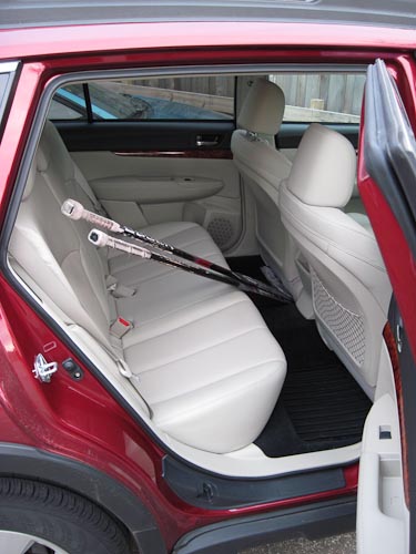
Unfortunately, a couple of things don’t quite fit in the cargo area.  My hockey sticks, for example, need to ride in the rear seats.

The hockey sticks have to ride in the back

Then again, they don’t fit in the cargo area even when they are the only items present; they’re just too long.

Likewise, my camera gear is in the main passenger area, but that’s part of the plan to keep it easily accessible for impromptu photo opportunities.

During the actual trip, I'll probably keep the camera out of the bag so that it's even more handy

I’ll admit that a few things were missing from this experiment.

First, I forgot about my hiking boots.  Those will probably go in one of the rear footwells.

Second, I’ll probably want to have a cooler and a cache of reasonably healthy food so that I can cook for myself.

Finally, I haven’t actually tried traveling with this configuration of equipment.  I’m planning to do a couple of short test trips before the main trip, so it’s possible that I’ll need to radically alter my gear manifest.

Still, this early result is quite promising.